Western Canada
Yukon Territory - British Columbia - Alberta
July 2013
There are three German reports about this area. In these reports you will find maps about the tours and of course many pictures. You just have to click the corresponding links.
1. Yukon Territory - Canada's wild Northwest
Link to the German report: Yukon - Canadas wilder Nordwesten
We cross the border on the Top of the World Highway. Everywhere in Yukon the meadows are full of flowers. That's why there is a separate picture gallery about Yukon wildflowers (Wildblumen im Yukon Territory).
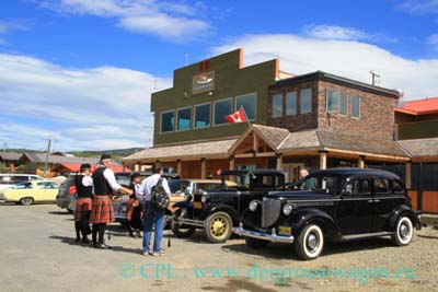
Soon we reach Dawson City where we have a look at the old buildings and SS Keno, a sternwheeler. The small town is very crowded because of the many tourists, so we soon leave.


We want to drive the Dempster Highway. The landscape is really impressive - at least for the first about 500 km (about 300 miles). Have a look at the picture gallery in the German Report We see a lot of wildlife: breeding semipalmated plovers, ptarmigans, and of course bear.


After 400 km (250 miles) we reach the Arctic Circle, soon we are in the Northwest Territories. We cross Peel River on the small ferry, now the landscape is getting more and more monotonous. Thus we only go as far as Fort McPherson - another 184 km (115 miles) of dirt road to Inuvik are too much.


We follow Klondike Highway which is not very impressive either, but the blooming flowers are. We want to drive the Campbell Highway from Carmacks to Watson Lake. And we want to go as far as possible on North Canol Road (a hot tip of an American). We enjoy the flowers and the view of the Yukon river.


In Faro we get to know that North Canol Road is closed due to flooding and that it is not advisable driving Campbell Highway because of wildfires. As an alternative route we take South Canol Road which proves to be a good decision. It is quite scenic, but there are a lot of mosquitoes and no sees.


After a couple of days we reach the Alaska Highway. Again we go westwards to Jake's Corner, where we turn on Atlin Highway. The view of the Atlin Lakes is very nice, the small town of Atlin is worth a visit because of nice old buildings, SS Tarahne, but most of all because of the wonderful surrounding.


Back on the Alaska Highway we go east. In Teslin we admire the totem poles at Teslin Tlingit Heritage Center.

2. Beautiful British Columbia
Link to the German report: British Columbia
For our way back we choose Cassiar Highway. There is less traffic than on the Alaska Highway, but we think there are a lot more trucks on the road compared with 2009. There is a lot of blooming along the roadside, too.
The landscape along the Cassiar Highway is very beautiful. Mount Edzidza is one of the most remarkable spots. We go kayaking, enjoy the views and even have the chance of observing an owl very closely.


Later we take Stewart Highway down to the town of Steward. Near Bear Glacier we spend the night, hummingbirds are regular visitors of our feeder.

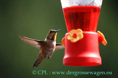
Soon we reach Hyder, Alaska without crossing an official border station. The salmon aren't running yet, so there are no bears. We take the dirt road up to Salmon Glacier. Up there we admire the stunning views of Salmon River Valley and the glacier. And even here are a lot of hummingbirds.


Back at Fish Creek the salmon still haven't arrived. But we are able to observe a river otter. We wait another day - but nothing. Luckily we saw the fishing bears four years ago (click the link).

Along the road the ditches are covered with (very tall) orchids. And we often see black bears crossing the road. In Gitanyow and Gitwangak there are a lot of (old) totem poles. Now we follow the Yellowhead Highway which is not very impressive. But Old Hazelton with its Ksan Village and Smithers are nice stops. The closer we get towards the Rockies the better the views are.


Before we enter Jasper National Park we spend the night near Mount Robson and enjoy the scenic panorama.

3. Alberta: Mountains, glaciers, badlands, dinosaurs
Link to the German report: Alberta
After a short stop in the town of Jasper we travel along Icefield Parkway. There is a lot of traffic, so we take the lesser crowded 93 A in the upper part, but even here it is very busy. But the landscape is absolutely impressive, many flowers are in bloom - gorgeous!


The sunrise at Moraine Lake is picturesque, too, although the weather has changed and it is a bit cloudy. And because we are here very early in the morning we see a lot of pikas.


In the town of Banff we are lucky, there is a performance of traditional First Nation dances.
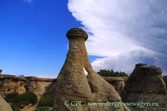
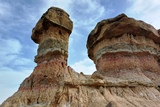
On our way to the Canadian badlands the landscape is a little monotonous, but the badlands are worth the way. You can find them near Drumheller, in Dinosaur Provincial Park and in Writing on Stone Provincial Park.
In Drumheller you do not only find badlands and hoodoos, but a world famous museum: the Royal Tyrrell Museum, Canada's only museum of palaeontology. We are absolutely thrilled by the display of dinosaurs and other fossils. You must look at the picture gallery in the German report!


Dinosaur Provincial Park is renowned for its fossils (a lot of the dinosaurs in the a.m. museum have been found here) and for its stunning badlands. A large portion of the park is only accessible through guided programs, but there are self-guided trails that lead you through fantastic badlands and hoodoos.

Writing on Stone PP got its name because of many pictographs and petroglyphs. You can only see them on guided tours. But some self-guided tours take you into beautiful hoodoo areas.
We now leave Canada and go back to the US.
Überwintern auf den Kanaren 2023/2024
09. April 2024
Auf der Rückfahrt durch Aragonien und Frankreich nach Deutschland erkunden wir in Spanien noch zwei weitere Highlights auf dieser Tour.
Überwintern auf den Kanaren 2023/2024
28. März 2024
Für die Rückreise beschließen wir, mehr oder weniger die gleiche Strecke wie auf dem Hinweg zu fahren, allerdings mit einigen Abweichungen. Wir wollen nämlich noch uns bisher nicht bekannte Ziele ansteuern.

Überwintern auf den Kanaren 2023/2024
25. März 2024
Nach 105 Tagen auf den Kanaren haben wir unsere Erfahrungen zusammengefasst. Vieles war positiv, aber insgesamt überwiegen die negativen Eindrücke zu einer Überwinterung mit dem Wohnmobil auf den Kanarischen Inseln.


 | Today | 4019 |
 | Yesterday | 4346 |
 | This_Week | 19944 |
 | This_Month | 100001 |
 | Total | 2486019 |